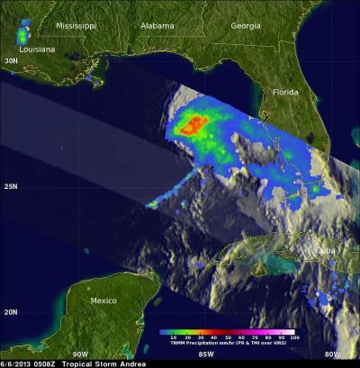
NASA's Tropical Rainfall Measuring Mission (TRMM satellite) flew directly above tropical storm Andrea on Thursday, June 6, 2013 at 0508 UTC (1:08 a.m. EDT). This orbit showed that Andrea had a large area of moderate to heavy rainfall in the northeast quadrant of the storm and precipitation was spreading over the state of Florida.
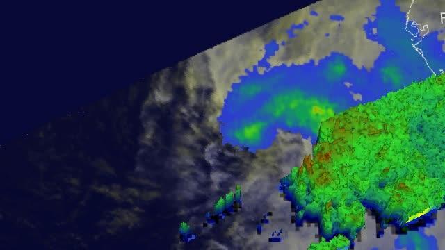
At NASA's Goddard Space Flight Center in Greenbelt, Maryland, Hal Pierce of the TRMM Science Team used TRMM data create a 3-D view of Tropical Storm Andrea. The 3-D view from the west was derived from TRMM Precipitation Radar (PR) data captured when Andrea was examined by the TRMM satellite with the June 5, 2234 UTC (6:34 p.m. EDT) orbit.
It clearly showed that the majority of the heavy convective rainfall was located on Andrea's eastern side. TRMM PR also showed that the tallest convective thunderstorms reached heights of about 14 km (~8.7 miles).

This 3-D view from the west was derived from TRMM Precipitation Radar (PR) data captured when Andrea was examined by the TRMM satellite with the June 5, 2234 UTC (6:34 p.m. EDT) orbit. It clearly shows that the majority of the heavy convective rainfall was located on Andrea's eastern side. TRMM PR also showed that the tallest convective thunderstorms reached heights of about 14km (~8.7 miles). Credit: SSAI/NASA, Hal Pierce
On June 6, at 2 p.m. EDT, Tropical Storm Andrea was located near 29.0 north and 83.6 west. That's just 35 miles west-southwest of Cedar Key, Florida and 100 miles east-southeast of Apalachicola. Andrea's maximum sustained winds were near 60 mph (95 kph) and had slightly increased forward speed, moving northeast at 17 mph (28 kph). Minimum central pressure is 994 millibars, down from 997 millibars during the morning hours.
At 2 p.m. EDT, the National Hurricane Center noted that the center of Andrea will reach the coast of the big bend area of Florida in the next few hours.
A Tropical Storm Warning is in effect for the west coast of Florida from Boca Grande to Indian Pass, from Flagler Beach, Fla. to Cape Charles Light, Va., the Pamlico and Albemarle Sounds, and the lower Chesapeake Bay south of New Point Comfort, Va.
Andrea is expected to move northeastward after crossing Florida and travel near the east coast of the United States through Saturday, June 8.

TRMM showed that Andrea had a large area of moderate to heavy rainfall in the northeast quadrant of the storm and precipitation was spreading over the state of Florida. The cloud cover extended over the northern half of Florida, but was out of range of TRMM's orbit. Credit: SSAI/NASA, Hal Pierce

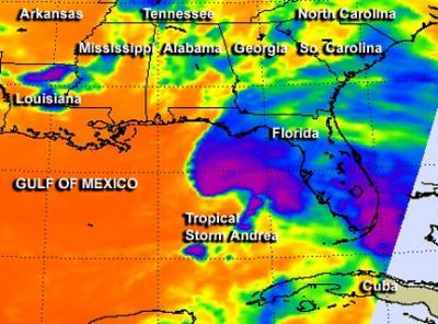
Infrared image of the temperatures of Tropical Storm Andrea's cloud tops was taken by the AIRS instrument aboard NASA's Aqua satellite on June 6 at 2:41 a.m. EDT. The dark purple indicates coldest cloud top temperatures (in excess of -63F/-52C) and heavy rainfall. At that time, most of the heaviest precipitation was over the eastern Gulf of Mexico and southeastern Florida. Credit: NASA JPL, Ed Olsen
SUMMARY At 5:00 PM EDT...2100 UTC
----------------------------------------------
LOCATION...29.5N 83.4W
ABOUT 35 MI...55 KM NNW OF CEDAR KEY, FLORIDA
ABOUT 80 MI...130 KM SE OF TALLAHASSEE, FLORIDA
MAXIMUM SUSTAINED WINDS...65 MPH...100 KM/H
PRESENT MOVEMENT...NE OR 40 DEGREES AT 17 MPH...28 KM/H
MINIMUM CENTRAL PRESSURE...993 MB...29.32 INCHES
For the most up to date forecasts, visit the National Hurricane Center web page at: http://www.nhc.noaa.gov.


Comments