NASA's Tropical Rainfall Measuring Mission (TRMM) satellite was able to estimate rainfall rates of Typhoon Bopha over the Philippines, where severe flooding killed several hundred people. Bopha is now a tropical storm in the South China Sea but high winds, flooding and landslides from heavy rains with Typhoon Bopha have caused close to 300 deaths in the southern Philippines.
Why was it a typhoon rather than a hurricane? Tropical cyclones west of the International dateline but in the NW Pacific are counterclockwise. Hurricanes are clockwise in the southern hemisphere and counterclockwise in the northern hemisphere of the southern Pacific and North Atlantic.
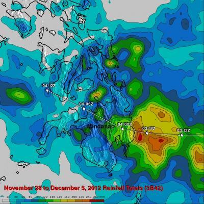
The TRMM satellite's primary mission is the measurement of rainfall in the tropics. A near-real time Multi-satellite Precipitation Analysis (MPA) using TRMM satellite data was created at the NASA's Goddard Space Flight Center in Greenbelt, Md. the MPA monitors rainfall over the global Tropics. MPA rainfall totals from Typhoon Bopha were compiled for the period from November 28 to December 5, 2012 when typhoon Bopha was moving through the southern Philippines.
The MPA analysis shows that the heaviest rain, estimated at over 240 mm (~9.4 inches), was located near the coast of eastern Mindanao where the typhoon first hit the island. Rainfall totals of over 100mm (~3.9 inches) covered a large area of eastern Mindanao. Because Bopha was moving relatively fast, it kept rainfall totals down.

TRMM rainfall totals are shown here from Nov. 28 to Dec. 5, 2012 when typhoon Bopha was moving through the southern Philippines. Typhoon Bopha's track is shown overlaid in white. The heaviest rain, estimated at over 240 mm(~9.4 inches), was located near the coast of eastern Mindanao where the typhoon first hit the island. Rainfall totals of over 100mm (~3.9 inches) were normal over a large area of eastern Mindanao. Credit: NASA/SSAI, Hal Pierce
Thursday, Dec. 6 at 1500 UTC (10 a.m. EST, U.S.), Bopha had weakened to a tropical storm with maximum sustained winds near 55 knots (63 mph/102 kph). At that time, Bopha's center was located near 13.0 north latitude and 116.2 east longitude, about 295 nautical miles west-southwest of Manila, Philippines. Bopha was moving to the north-northwest at 4 knots (4.6 mph/7.4 kph) and is expected to continue in that general direction over open waters for the next couple of days.
Infrared satellite imagery has shown that the strongest convection (rising air that condenses and creates the thunderstorms that make up the tropical cyclone) around the center was weakening, and the center was elongating. Bopha is in an area of moderate vertical wind shear which is helping to elongate and weaken the storm. Cooler waters and a northeasterly monsoon surge will help to weaken Bopha over the next couple of days.

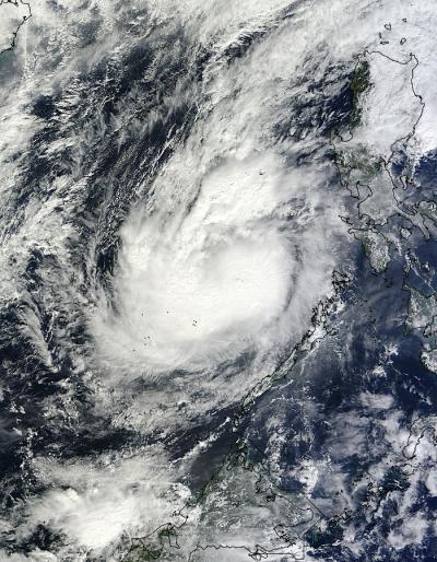
The MODIS instrument aboard NASA's Aqua satellite captured this visible image of Typhoon Bopha moving through the South China Sea on Dec. 6 at 03:00 UTC (10 p.m. EST, U.S, Dec. 5). Credit: NASA Goddard MODIS Rapid Response Team


Comments