Two NASA satellites, Terra and the Tropical Rainfall Measuring Mission (TRMM) , gathered data as a Super Typhoon passed over Bopha on Dec. 2nd, gathering valuable data for forecasters. Since then, Bopha's maximum sustained winds fluctuated up and down from its previous high of 155 mph and today, Dec. 3rd, the storm reached its strongest point - a Category 5 typhoon on the Saffir-Simpson scale, with sustained winds of 161 mph. Warnings are up for the Philippines as Bopha approaches.
Terra captured a visible image of Bopha showing the extent of the storm and revealing the eye of the storm while TRMM captured rainfall rates, identified areas of heavy rainfall, and measured cloud heights.
On Dec. 1st at 1000 p.m. CHST (1200z/7 a.m. EST/U.S.) the center of Typhoon Bopha was located near latitude 5.4 degrees north and longitude 140.1 degrees east. That placed Bopha's center about 270 miles southeast of Ngulu and about 315 miles south-southeast of Yap. Maximum sustained winds were up to 130 mph.
When NASA's TRMM satellite passed over Typhoon Bopha at 0402 UTC on Dec. 1 (Nov. 30 at 11:02 p.m. EST/U.S.) it captured an image of the storm that clearly revealed an eye. It also showed tight circulation and an expanded area of very heavy rainfall located from southwest to southeast of the center of circulation where rain was falling at a rate of 2 inches/50 mm per hour.

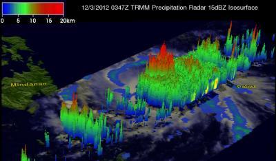
At 0347 UTC on Dec. 3, NASA's TRMM satellite flew above a dangerous typhoon Bopha. Joint Typhoon Warning Center (JTWC) to hit the island of Mindinao in the Philippines with winds of 135 kts (155 mph) later today. This 3-D image from TRMM's Precipitation Radar showed some strong convective thunderstorms on the eastern side of Bopha's eye were reaching heights of over 16 km (~9.94 miles). A TRMM analysis showed that Bopha had a well-defined eye with very heavy rain falling at a rate of over 80mm/hr (~3.1 inches) falling in the eye and in intense rain bands spiraling around the eye. Credit: NASA/SSAI, Hal Pierce
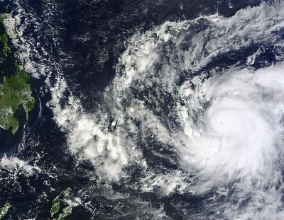
The next day, Dec. 2, 2012 at 0145 UTC (Dec. 1 at 7:45 p.m. EST), the Moderate Resolution Imaging Spectroradiometer (MODIS) instrument on NASA's Terra satellite captured a visible image of Super Typhoon Bopha approaching the Philippines. The visible image showed a tightly wound center of circulation, with the eye obscured by high clouds. At the time of this image, Bopha's maximum sustained winds were near 155 mph, a powerful Category 4 super typhoon on the Saffir-Simpson scale.
NASA's TRMM satellite captured rainfall data on Super typhoon Bopha on Dec. 2 at 1435 UTC (9:35 a.m. EST) and showed areas of heavy rainfall spanned from the northeast to the southern quadrant of the eye. The heaviest rain was falling at a rate of more than 2 inches (50 mm) per hour.
On Dec. 3 at 1 p.m. CHST local time, (0300 UTC/10 p.m. EST/U.S., Dec. 2) the eye of Typhoon Bopha was located near latitude 6.9 degrees north and longitude 130.9 degrees east. This is about 140 miles northwest of Sonsorol and 240 miles west of Koror. At that time, maximum sustained winds had dropped to 120 mph.
Six hours later, Bopha had again intensified as its maximum sustained winds were up to 130 mph. Bopha's typhoon-force-winds extend outward up to 35 miles from the center, or 70 miles in diameter. Tropical-storm-force winds have a much greater reach and extend outward up to120 miles from the center, making tropical-storm force winds reach over 240 miles in diameter.
At 7 p.m. CHST local time (0900 UTC/4 a.m. EST, U.S.) on Dec. 3, the National Weather Service in Guam reported that "the eye of Typhoon Bopha was located near latitude 7.0 degrees north and longitude 129.7 degrees east. That put the center about 210 miles northwest of Sonsorol, 325 miles west of Koror and 350 miles west-southwest of Kayangel. Typhoon Bopha was moving west at 14 mph and expected to turn to the west-northwest. The National Weather Service in Guam issued their final advisory on the storm with this position, and forecasting for the storm will be covered by the Joint Typhoon Warning Center and the Philippine Atmospheric, Geophysical and Astronomical Services Administration known as PAGASA.

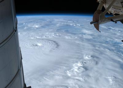
This astronaut photo of Super Typhoon Bopha was taken on Sunday, Dec. 2 from the International Space Station, by Astronaut Ford as the Category 4 storm bore down on the Philippines with winds of 135 mph. Credit: NASA ISS
Bopha Now a Category 5 on the Saffir-Simpson Scale
Bopha reached Category 5 status on the Saffir-Simpson Scale for the first time today, Dec. 3. Over the last several days it peaked at a powerful Category 4 typhoon. On Dec. 3 at 1500 UTC (10 a.m. EST, U.S.), Bopha had regained Super Typhoon status as maximum sustained winds increased to 140 knots (161 mph/259 kph). Bopha was located near 7.6 north latitude and 128.2 east longitude, about 630 nautical miles (725 miles/1,167 km) southeast of Manila, Philippines. Bopha is moving to the west-northwest at 16 knots (18.4 mph/29.6 kph). Infrared satellite imagery shows a well-developed, intense system that has a 9 nautical-mile (10.3 mile/16.6 km) wide eye.
Current warnings in the Philippines
All regional warnings for the Federated States of Micronesia have been canceled and replaced by warnings for the Philippines. In the Philippines, Bopha has been given the name "Pablo," and local updates from PAGASA can be found at: http://www.pagasa.dost.gov.ph/wb/tcupdate.shtml.
PAGASA posted Public Storm Warning signal #3 over the Mindanao provinces of Surigao del Norte and Sur, Siargao, Dinagat Province, Agusan del Norte and Sur, Misamis Oriental, Camiguin, Bukidnon, Davao Oriental, Compostela Valley, Davao del Norte and Samal Island. In addition, Public Storm Warning Signal #2 is effect in the Mindanao provinces of Misamis Occidental, Lanao del Norte and Sur, North Cotabato, Davao del Sur and Zamboanga del Norte; and in the Visayas provinces of Southern Leyte, Bohol, Southern Cebu, Negros Oriental and Siquijor. Public storm warning signal #1 is in effect for the Mindanao provinces of Zamboanga del Sur, Maguindanao, Sultan Kudarat, Sarangani and South Cotabato; the Visayas provinces of Eastern and Western Samar, Leyte, Biliran, Aklan, Capiz, Antique, Iloilo, Guimaras, Negros Occidental, Rest of Cebu and Camotes Island; the Luzon provinces of Northern Palawan, Calamian group of islands and Cuyo Island.
The Joint Typhoon Warning Center expects Bopha to make landfall in the Visayas region of the Philippines around 2300 UTC on Dec. 3 (6 p.m. EST, U.S.) and weaken as it moves on a west-northwest to northwesterly track through central Mindanao before exiting into the South China Sea.

The MODIS instrument on NASA's Terra satellite captured this visible image of Super Typhoon Bopha approaching the Philippines on Dec. 2, 2012 at 0145 UTC (Dec. 1 at 7:45 p.m. EST). Credit: : NASA/MODIS Rapid Response Team


Comments