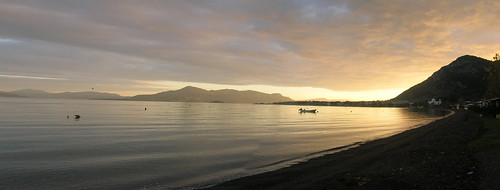
This photo was taken early one winters day as we were preparing to head out into the field. At first glance, the geology in this picture is not obvious, unless you know a little of the geology of mainland Greece. Greece is being stretched, and this leads to a series of normal faults. One side of these faults is raised up, the other drops down. The Gulf of Evia, pictured below, was formed by one of these faults. It is still growing today, slowly.
In the photo below, you can actually see the fault. If you look at the hill on the very right, you should see a long, flat surface towards the bottom, at about 45º. That is the fault. The hill to the right has been raised up out of the sea. All over central Greece there are similar scarps.
The other geological feature you can see is he large, flat bit of land, sticking out into the gulf. When the faults lift hills up into the air, gravity begins to get to work. The highs get eroded, and the sediment gets transported to the lows. In this case, sediment gets transported into the gulf. The flat piece of land in the picture is a delta, that has built out as the fault grows.
For most fault systems it is hard to reconstruct the vertical motions. We have only been able to accurately survey faults for a century or two at best, and these things operate on a timescale of 10s to 100s of 1000s of years. In Greece, the interaction of the faults with the sea gives us an opportunity to map out the history of the area.


Comments