A new paper believes that in an already seismically active Arctic region, permafrost degradation can weaken the ice that helps to bind fractures within rock. The frozen water within these fractures, which helped to stabilize the volcanic slopes for thousands of years, is losing its binding effect, which could lead to the rock failing more readily.
They cite satellite observations from the past 40 years show no evidence of earthquake-triggered rock avalanches with a comparable debris extension and interpret the newly-observed instability as the result of long-term changes to the climate.
‘Permafrost’ is, as the portmanteau reads like, permanently frozen ground. The rock is held together by ice so if the ice thaws, the ground becomes weaker, and unstable. If an an earthquake, hazards rise dramatically. The paper investigated one in March of 2025, 6.5 moment magnitude scale earthquake that shook Jan Mayen island in the northernmost part of the Atlantic Ocean whose political owner is Norway. A rock avalanche followed and covered part of a glacier with rock and debris mounds known as molards about three miles from the epicenter.
Beerenberg, an active volcano there, has glaciers that stretch from the rim a mile to the coast and two of them were impacted by the earthquake. The Kjerulf Glacier experienced an avalanche while Weyprecht Glacier experienced earthquake-induced calving of ice.
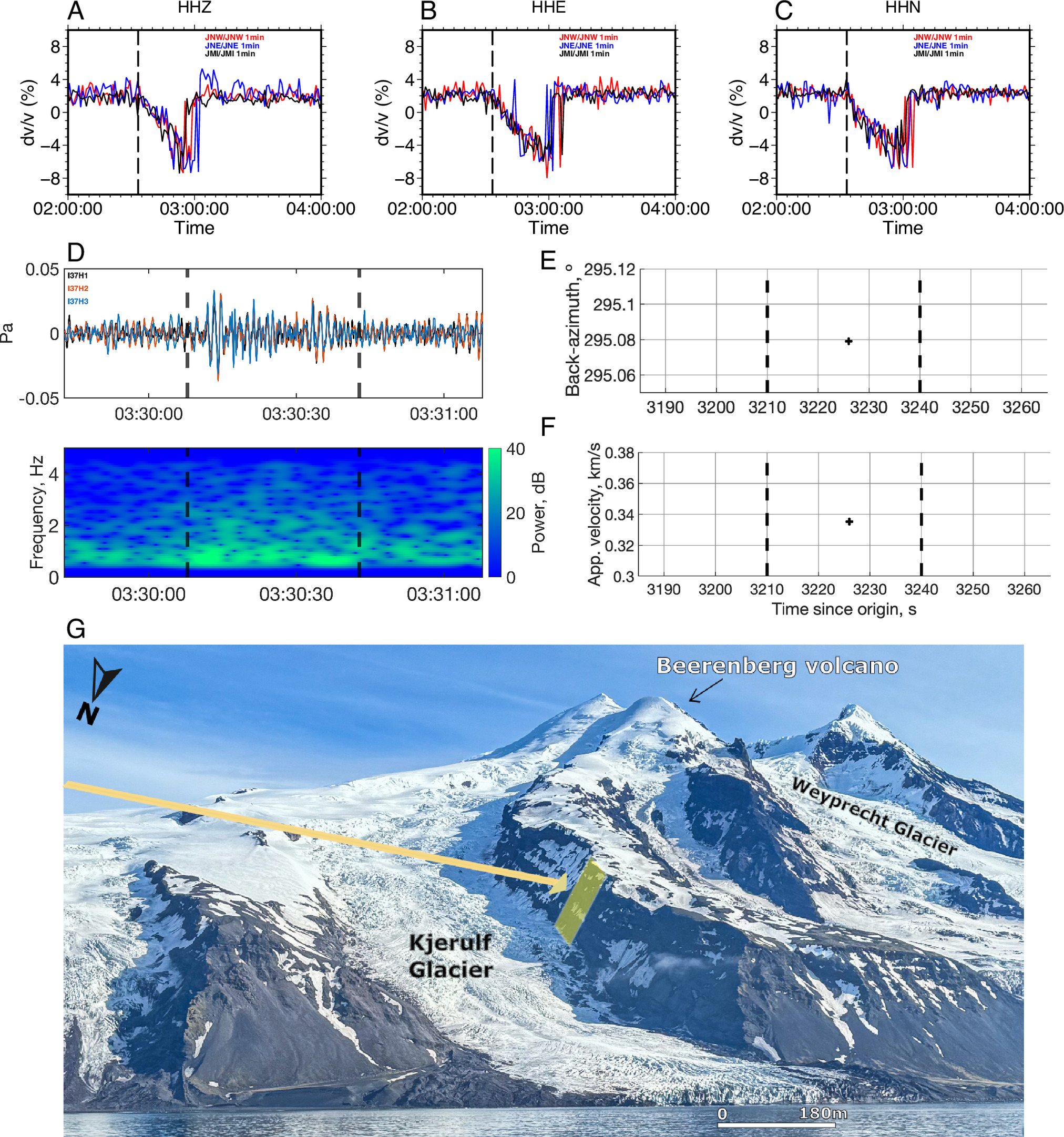
Seismic velocity changes, infrasound, and local view of the Kjerulf Glacier. (A–C) show relative seismic velocity changes (dv/v) at the onset of seismic rupture and ground motion are observed at the three local seismic stations on Jan Mayen. The vertical black dashed line indicates the mainshock origin time measured by the local seismic stations (02:33:15.8 UTC). (D) Top: acoustic signal recorded by the infrasound sensors of the NORSAR (39) CTBTO (vDEC, network presented by the black/red/blue waveforms. The vertical black dashed lines indicate the signal range cross-correlated in analysis using the back-azimuth approach (7). Bottom: spectrogram of the same signal plotted in the Upper part of (D). (E) Back‐azimuth obtained from cross‐correlation of three‐infrasound pairs is presented by the black cross on top plot. The apparent velocity referent of the infrasound propagation is shown on (F). (G) Orthogonal structure view (northward) of the Kjerulf glacier and Beerenberg volcano at south, before the earthquake. Image adapted from original photographed by Robert Michael Poole, 27 June 2024. (with permission). Yellow 40% transparent shape indicates the rock avalanche source area along the south basaltic wall. The back-azimuth direction obtained by the infrasound signal is shown by the yellow arrow.
To reach their conclusion that climate change made it worse than it would've been in the past, they created a computer model which contained seismic data, satellite imagery, infrasound measurements plus air temperature and climate records.
Citation: Guilherme W. S. de Melo, Reginald L. Hermanns, Jacob M. Bendle, Ingo Grevemeyer, Sylvain Fiolleau, Simone Cesca, Aderson F. do Nascimento, Lars Ottemöller, Gökhan Aslan, Quentin Brissaud, Volker Oye, Heidrun Kopp, Earthquake-triggered cascading hazards under Arctic amplification, Proc. Natl. Acad. Sci. U.S.A. 123 (38) e2617210123, DOI: 10.1073/pnas.2617210123 (2026).