Low pressure areas that dropped more than a foot of snow in some Midwestern states have prompted many warnings and weather advisories. Satellite data recently got a look at a major snowstorm.
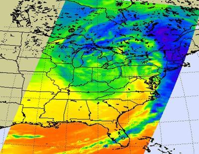
On Dec. 21st, 2012, at 0729 UTC (2:29 a.m. EST), the Atmospheric Infrared Sounder (AIRS) instrument that flies aboard NASA's Aqua satellite captured an infrared image of the massive low pressure area that caused a major snowstorm in the Midwest and beyond.
The AIRS infrared image was false-color enhanced to show temperatures. In the false color image, the darkest blue and purple areas indicate the highest clouds and coldest cloud top temperatures, where precipitation is heaviest. Those coldest cloud top temperatures were near 220 kelvin (-63.6 Fahrenheit/-53.5 Celsius) and were over the New England states and southeastern Canada. Those were also areas where the heaviest precipitation was falling.
The infrared image also showed that the low pressure center of circulation was located over northern Ohio. The southern extent of the storm brought wind damage to Alabama and spawned tornadoes in Arkansas. AIRS imagery is created at NASA's Jet Propulsion Laboratory in Pasadena, Calif.

On Dec. 21 at 2:29 a.m. EST, the AIRS instrument aboard NASA's Aqua satellite captured this infrared image of the massive low pressure area that caused a major snowstorm in the Midwest and beyond. The darkest blue and purple (-63.6 Fahrenheit/-53.5 Celsius) areas indicate the highest clouds and coldest cloud top temperatures, where precipitation is heaviest. Credit: NASA JPL, Ed Olsen
According to USA Today, the storm had taken at least eight lives, caused about 1,000 flight cancelations and power outages, caused closures of schools and government offices, multiple car accidents and road closures and dropped more than a foot of snow in parts of Wisconsin and Iowa. The National Weather Service noted that the storm system caused Blizzard Warnings in Minnesota, Wisconsin, Illinois and Iowa. The storm also triggered Winter Weather Advisories from Washington state to Maine and covered parts of 17 states.
NOAA's GOES-13 satellite monitors weather over the eastern half of the U.S. from a fixed orbit in space. Imagery from GOES-13 was compiled into an animation by NASA's GOES Project at the NASA Goddard Space Flight Center in Greenbelt, Md. that showed the movement of the storm from Dec.19 through the morning of Dec. 21. Over that time, the animation shows a long line of clouds from a cold front that stretched from Canada to the U.S. Gulf Coast move west to east. The cold front is associated with a low pressure center that moves in from the west as the animation begins and reaches northern Ohio by the time the animation ends on Dec. 21 at 1445 UTC (9:45 a.m. EST).
On Dec. 21st, the National Weather Service noted, "Blizzard and Winter Storm Warnings remain in effect through Friday night (Dec. 21) or Saturday (Dec. 22) for the Great Lakes and central Appalachians, where heavy snow will combine with strong winds to produce dangerous travel conditions."


Comments